Post a reply

Image
Apr 25, 2016 2:38 PM CST
Name: Barbara
Northern CA (Zone 9a)
Region: California Cat Lover Dog Lover Irises Enjoys or suffers hot summers
Me too, Thank You!
• “Whoever said, ‘Do something right and you won’t have to do it again’ never weeded a garden.” – Anonymous
Image
Apr 25, 2016 3:00 PM CST
Name: Sherry Austin
Santa Cruz, CA (Zone 9a)
Birds Bulbs Region: California Dragonflies Foliage Fan Irises
Keeper of Poultry Roses Photo Contest Winner: 2015
I know... At first I thought this was a thread that I'd missed back in January.. That's when we have our storms.. I'm just dealing with wind today.. I have to go stake up a couple of rose standards that need some additional support, but nothing like the tornadoes or hurricanes here thankfully.
The surest sign that intelligent life exists elsewhere in the universe is that it has never tried to contact us.
Image
Apr 25, 2016 3:23 PM CST
Thread OP
Name: John
Kansas City,MO (Zone 6a)
Composter Region: Missouri Plays in the sandbox Enjoys or suffers cold winters
I know it looks real calm right now, but all forecast models are in strong agreement that the next 24-36 hours will bring a severe storms event from Oklahoma to here in Missouri. Tornados and large hail are a real possibility for us in the KC area. I'll post some official NWS forecasts when we get up at 0200 local.
See you all in the morning.

Blessings
When they call the roll in the Senate, the Senators do not know whether to answer 'Present' or 'Not guilty.' Theodore Roosevelt
Image
Apr 26, 2016 1:52 AM CST
Thread OP
Name: John
Kansas City,MO (Zone 6a)
Composter Region: Missouri Plays in the sandbox Enjoys or suffers cold winters
Good morning,

This afternoon and evening look to be quite active for severe weather events in a rather large area. Here is a NOAA map that is fairly recent;

Thumb of 2016-04-26/yadah_tyger/558b81

The primary focus remains in the Oklahoma City area but the last scientific forecasts I read from last night for Dallas and Kansas City were not encouraging. Minimally all these areas will see hail and straight line winds at a minimum. The likelihood of tornado activity is fairly high, especially in Oklahoma, Kansas and Missouri.

I'll post the latest guidance from NWS as soon as it becomes available. I know we have friends in the Dallas/Fort Worth and Enid besides my wife and I here in KC. Prayers would be a good thing.

This is the first time I have gone around my home to find a 'safe place'. There is none. But we do have a solid oak bed that was hand built by the horse & buggy folks in Pennsylvania. It is solid. If push comes to shove we will crawl under the bed. Having a plan, just in case, is always the smart thing to do.

Blessings & stay safe
When they call the roll in the Senate, the Senators do not know whether to answer 'Present' or 'Not guilty.' Theodore Roosevelt
Image
Apr 26, 2016 2:59 AM CST
Thread OP
Name: John
Kansas City,MO (Zone 6a)
Composter Region: Missouri Plays in the sandbox Enjoys or suffers cold winters
For you folks in the DFW area. Here is the latest guidance from NWS;

"The resulting negatively tilted appearance taken on by the upper level system is generally conducive for the development of strong to severe thunderstorms...particularly in the Spring when other parameters associated with convection are more likely to become favorable. One such parameter will be low level convergence...which in this case will be enhanced as a dryline is nudged eastward into western counties of north and central Texas. Another will be instability...which is forecast to be in great supply as cape climbs to near 4000 j/kg in the vicinity of the dryline this afternoon. Shear will be more than sufficient for the development of rotating cells capable of maintaining strong updrafts...which means that large hail will be our most likely severe threat. Damaging downburst winds will also be a good possibility with any storms which becomes severe. Low level shear does not look particularly great for an outbreak of tornadoes...but when combined with such good instability will be enough for a few tornadoes to occur. The highest probabilities for severe thunderstorm development will be early on in the development of storms...or during the 4 to 10 PM time-frame when discrete cells are more likely to occur. Location should initially be west of the Interstate 35/35w corridor near the dry-line. Upscale development into a linear convective Mode is likely late this evening and overnight as storms shift east across the I-35 corridor and continue across the eastern half of the region. Brief heavy rain and localized flooding will be another possible threat overnight...especially if any storms are able to train over the same areas. Activity is expected to end from west to east during the morning hours on Wednesday. "

The key wording here is "Shear will be more than sufficient for the development of rotating cells" which means large hail is possible. But the god news is "Low level shear does not look particularly great for an outbreak of tornadoes". So hail and maybe straight line winds are likely.

Still in all, stay alert, especially late this afternoon and early evening.

Blessings
When they call the roll in the Senate, the Senators do not know whether to answer 'Present' or 'Not guilty.' Theodore Roosevelt
Image
Apr 26, 2016 4:04 AM CST
Thread OP
Name: John
Kansas City,MO (Zone 6a)
Composter Region: Missouri Plays in the sandbox Enjoys or suffers cold winters
Guidance for the KC area just came out of NWS. A little bit of good news;

"Early morning elevated convection will continue to fire south of a stationary frontal boundary draped across northeast Kansas and northern Missouri. A Stout eml will continue to support modest instability with further destabilization through the morning hours. Storms early on will be relatively isolated and should remain north of the I-70 corridor until daybreak. Overnight convection has been slow to strengthen given the lack of instability, though should start to see more widespread development in the early to mid morning hours. A larger cluster of storms developing over north central Kansas, where more supportive instability is present, will likely generate a cold pool sufficient enough to steer nearby convection to the southeast. As these elevated storms strengthen after daybreak, some storms may produce large hail until the mid morning. As this activity slides to the southeast through the late morning to early afternoon, there should be a bit of a break in the activity until the late afternoon and early evening hours. The anticipated deep upper low will center across western Kansas while at the surface, a dryline will reside from central Texas up to south central Nebraska. Morning convection may limit instability to a degree, though cloud cover should thin out enough to generate surface based cape values over 2000 jkg by the mid afternoon. More robust convection will fire along the dry line well to the west of the area through the early afternoon. This convection will then slide into eastern Kansas and western Missouri by the late afternoon. Will also need to monitor the potential for convection ahead of the dryline within an area of surface convergence. As the storms over eastern Kansas approach the area, will likely transition to a linear Mode with bowing segments. Large hail and damaging winds will be the primary hazards, particularly for western Missouri, though a few embedded tornadoes cannot be ruled out. "

The key to this forecast is what is happening right now in our area. Thunderstorms are forming to our north and missing us. And the dry line is nearly stationary. This means those storms will stay to our north. For now. The severe outlook for later this afternoon remains. But there is a bit of good news. Again, from NWS;

" As the storms over eastern Kansas approach the area, will likely transition to a linear Mode with bowing segments. Large hail and damaging winds will be the primary hazards, particularly for western Missouri, though a few embedded tornadoes cannot be ruled out."

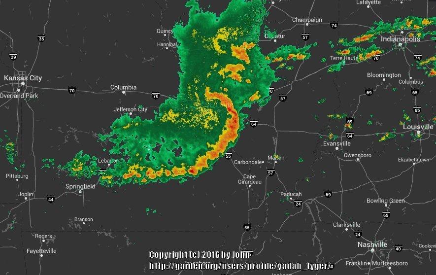
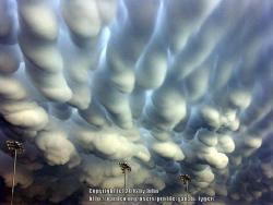
So, the bottom line, the primary threat will be large hail and wind, but no tornadoes. If you have the time, I'll post the radar site and you can watch what a bowing line of thunderstorms looks like. It's fairly impressive. One thing you can count on when you a get a bowed line of thunderstorms, wind!! If you are in these areas where severe weather is forecast and it is safe to do so, go outside and see if you can spot mammatus clouds. Here's what they look like;


Thumb of 2016-04-26/yadah_tyger/3f84b5

Blessings
When they call the roll in the Senate, the Senators do not know whether to answer 'Present' or 'Not guilty.' Theodore Roosevelt
Image
Apr 26, 2016 4:12 AM CST
Thread OP
Name: John
Kansas City,MO (Zone 6a)
Composter Region: Missouri Plays in the sandbox Enjoys or suffers cold winters
And for the Norman, OK area. This from NWS;

"Discussion... big picture still shows the potential of a significant severe weather day across the area. The primary takeaway is that although there are some uncertainties discussed below... residents of Oklahoma and North Texas should remain alert today for the potential of severe weather and tornadoes and should not focus on the minutia of the more uncertain timing and evolution details of the forecast. On the large scale... the airmass over the area will become very unstable and the primary upper wave is prognosticated to approach western Oklahoma at 00z... well timed for storm development late this afternoon and evening. The instability will definitely support high-end severe storms with very large hail. Severe storm development is likely this afternoon/evening. But the devil is in the details and a number of questions remain about specific evolutions. First is timing. Although timing of the main wave looks reasonable... satellite has shown middle/high clouds developing from El Paso northeast toward Guymon hinting at a feature that does not appear to be resolved by the models. Would really like to see wind profiler data at the old White Sands and Tucumcari profiler sites to see what is happening here. But as clouds develop and satellite can begin estimating middle/upper level winds here...current GOES estimates are 70-85 knots around 300 mb and even 70 knots around 500 mb... much higher than prognosticated...so do not have high confidence that any affect from this apparent enhancement are resolved in any way by the models. This leads to uncertainty about if this will support an earlier initial wave of development and if so... how will that affect the evolution later today. Will not include probability of precipitation too early in this package... but will closely watch evolution. On the other side... with a relatively Stout capping inversion... there is a decent chance that convective development also may be delayed until later as well. Second question is tornado potential. Low-level and deep-layer shear certainly support tornadoes today. But again looking at the details... most forecast hodographs show a veeing/backing/ veering profile with height which is not necessarily conducive to long-lived tornadic storms. But again while it is important to note these uncertainties from a forecast perspective... the big picture remains the same that severe weather is likely and there is a potential for high-end severe storms /especially very large hail/ as well as the potential for tornadoes."

The key paragraph is the last one;

" Second question is tornado potential. Low-level and deep-layer shear certainly support tornadoes today. But again looking at the details... most forecast hodographs show a veeing/backing/ veering profile with height which is not necessarily conducive to long-lived tornadic storms. But again while it is important to note these uncertainties from a forecast perspective... the big picture remains the same that severe weather is likely and there is a potential for high-end severe storms /especially very large hail/ as well as the potential for tornadoes".

Bottom line, this event will be severe in your area. Wind, hail, dangerous lightning. But the bit of good news is the atmosphere will not likely not support long duration tornados, if tornadoes happen. This is good news. But be alert and stay safe.

Blessings
When they call the roll in the Senate, the Senators do not know whether to answer 'Present' or 'Not guilty.' Theodore Roosevelt
Image
Apr 26, 2016 8:01 AM CST
Thread OP
Name: John
Kansas City,MO (Zone 6a)
Composter Region: Missouri Plays in the sandbox Enjoys or suffers cold winters
Well, we are now getting the severe storms that were predicted for the morning event. NWS just hoisted the warning for us. Nice timing Jethro, where were you when that rouge bolt struck an hour ago when I was trying to get pictures. Note: Always have a change of pants during severe weather!!
When they call the roll in the Senate, the Senators do not know whether to answer 'Present' or 'Not guilty.' Theodore Roosevelt
Image
Apr 26, 2016 2:21 PM CST
Thread OP
Name: John
Kansas City,MO (Zone 6a)
Composter Region: Missouri Plays in the sandbox Enjoys or suffers cold winters
This is what a classic 'bow echo' looks like. This is happening right now over Saint Louis, MO.


Thumb of 2016-04-26/yadah_tyger/b36fd3
When they call the roll in the Senate, the Senators do not know whether to answer 'Present' or 'Not guilty.' Theodore Roosevelt
Image
Apr 26, 2016 3:05 PM CST
Thread OP
Name: John
Kansas City,MO (Zone 6a)
Composter Region: Missouri Plays in the sandbox Enjoys or suffers cold winters
The beginning of the severe event is now popping up right now just to our SW moving NE. This is also classic severe storm behavior. We will likely see very heavy rain starting in about an hour and contuining well into the late evening. Right now it is getting very dark. Looks like, for the KC area, NWS looks to be right on the money. Rats!!

If you are interested, go to the Wunderground link I posted and key in Kansas City MO and you can see how quickly these things can build.

Blessings
When they call the roll in the Senate, the Senators do not know whether to answer 'Present' or 'Not guilty.' Theodore Roosevelt
Image
Apr 26, 2016 3:34 PM CST
Name: Jane H.
Kentucky (Zone 6b)
Birds Region: Kentucky Clematis Daylilies Irises Region: United States of America
I can see that it will be heading toward Kentucky! I have heard that you should go to your bathtub if there is not a window in it as the plumbing usually stays intact and will provide some protection. Poor little iris plants may get a rough way to go!
Stay safe! Group hug
Image
Apr 26, 2016 3:43 PM CST
Thread OP
Name: John
Kansas City,MO (Zone 6a)
Composter Region: Missouri Plays in the sandbox Enjoys or suffers cold winters
Minus getting in a basement, the bathroom is next best. For us here, we did not get the afternoon sun, so I think tornado chances are low. But it looks like we will get training storms for a few hours.

Blessings
When they call the roll in the Senate, the Senators do not know whether to answer 'Present' or 'Not guilty.' Theodore Roosevelt
Image
Apr 26, 2016 3:50 PM CST
Thread OP
Name: John
Kansas City,MO (Zone 6a)
Composter Region: Missouri Plays in the sandbox Enjoys or suffers cold winters
A quick look at NWS for KY is calling for thunderstorms with heavy rain. Looks like you will be down range of what we are getting. Stay safe & dry.

Blessings
When they call the roll in the Senate, the Senators do not know whether to answer 'Present' or 'Not guilty.' Theodore Roosevelt
Image
Apr 26, 2016 3:55 PM CST
Name: Shannon
Burkeville,Va (Zone 7a)
The House on the Hill Gardens
Birds Seed Starter Sedums Roses Peonies Irises
Hostas Echinacea Dog Lover Daylilies Dahlias Cottage Gardener
Thank you so much for your weather reports Smiling we had a tornado a few years ago here in Va . a friend lost his house
always best to be prepared Thumbs up

When we purchased this home I made sure we had a basement .


Stay safe everyone Group hug
The horse is God's gift to mankind. ~Arabian Proverb
Image
Apr 27, 2016 1:23 AM CST
Thread OP
Name: John
Kansas City,MO (Zone 6a)
Composter Region: Missouri Plays in the sandbox Enjoys or suffers cold winters
You are welcome and very smart move. The safest place is below ground level.

Blessings
When they call the roll in the Senate, the Senators do not know whether to answer 'Present' or 'Not guilty.' Theodore Roosevelt
Image
Apr 27, 2016 1:30 AM CST
Thread OP
Name: John
Kansas City,MO (Zone 6a)
Composter Region: Missouri Plays in the sandbox Enjoys or suffers cold winters
Good morning,

Before I get into what is still going on in the KC area, I'll post some storm reports from Dallas and Oklahoma;

From Dallas;

04/26/2016 1104 PM
Garland, Dallas County.
Hail e0.88 inch, reported by trained spotter.
Nickel size hail reported by spotter at I-30 and Bobtown in Garland.

So we need to hear from Debra, she lives in Garland.


Quickly looking at OKC, I didn't see anything in the way of damage reports except for some barns SW of them.

So we need to hear from Lori, she lives in Enid.
When they call the roll in the Senate, the Senators do not know whether to answer 'Present' or 'Not guilty.' Theodore Roosevelt
Last edited by yadah_tyger Apr 27, 2016 1:39 AM Icon for preview
Image
Apr 27, 2016 1:58 AM CST
Thread OP
Name: John
Kansas City,MO (Zone 6a)
Composter Region: Missouri Plays in the sandbox Enjoys or suffers cold winters
Take a look at the National Radar Composite, this is one heck of a Spring storm event. The southern tip is in San Antonio TX and the northern tip is in South Dakota.

And now for us in the KC area.

Our event is still ongoing. But we have much good news to report. Well, it's good for us but not others. The hail missed our neighborhood. There are reports all around us of 1 to 1.5 inch hail. We got up at 2200 to the sound of very loud thunder and torrential rain. That lasted about an hour. But then the rain tapered off to just a steady rain, which we are still getting. But the lightening and thunder is still vivid to our SW. Overland Park, which is about 12 miles to our W/SW got hit with the 1.5 inch hail and strong winds. Plenty of new work for roofers I'm sure. But apart from hail and flooding, all looks well. When daylight breaks I'll take a look-see.

So, thank you Lord that there were no large tornadoes.

Blessings
When they call the roll in the Senate, the Senators do not know whether to answer 'Present' or 'Not guilty.' Theodore Roosevelt
Image
Apr 27, 2016 2:11 AM CST
Thread OP
Name: John
Kansas City,MO (Zone 6a)
Composter Region: Missouri Plays in the sandbox Enjoys or suffers cold winters
Today the Saint Louis area, including southern Illinois, need to stay sharp.

From NWS;

"Convection over eastern Kansas and northwest Missouri is proceeding slowly eastward...about as expected. Looks like the leading edges will be moving into the western fringes of our County warning forecast area by 06-07z. Have made minor tweaks to the pops to slow the precip accordingly. Rap is forecasting 1000-1500 j/kg of MUCAPE along with increasing deep layer shear...and this continues to point toward the possibility of elevated severe storms with severe hail being the primary threat."

Hail is the main threat for you guys.

Blessings
When they call the roll in the Senate, the Senators do not know whether to answer 'Present' or 'Not guilty.' Theodore Roosevelt
Image
Apr 27, 2016 5:52 AM CST
Thread OP
Name: John
Kansas City,MO (Zone 6a)
Composter Region: Missouri Plays in the sandbox Enjoys or suffers cold winters
Everything is cleared thru all the areas of main concern. That was quite a multi-state event!! At it's peak it stretched thru five states bringing severe weather to all of them. Glad it is over. Now on to deadheading all the destroyed blooms and waiting for the new ones.

If you live in areas that did get hit, please tell us how things look this morning.

Blessings
When they call the roll in the Senate, the Senators do not know whether to answer 'Present' or 'Not guilty.' Theodore Roosevelt
Image
Apr 27, 2016 5:55 AM CST
Name: Barbalee
Amarillo, TX (Zone 6b)
Thank you, Jon. This is all interesting information, and while I'm in the clear, lots of people aren't. I'll keep those spare pants handy!
Avatar is 'Global Crossing' 04-20-2017

Only the members of the Members group may reply to this thread.
Member Login:

( No account? Join now! )

Today's site banner is by SongofJoy and is called "Blue Pansies"

This site is protected by reCAPTCHA and the Google Privacy Policy and Terms of Service apply.