*cries*
http://www.denverpost.com/brea...
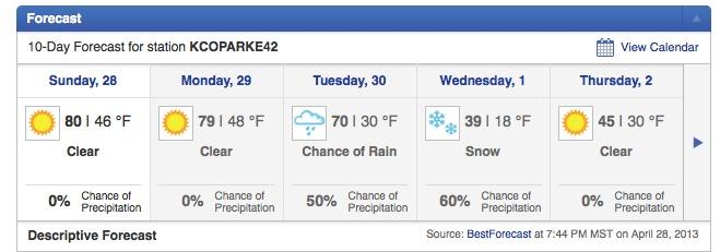
"We're looking at about 4 to 6 inches for the Denver metro area," Jim Kalina, a meteorologist with the National Weather Service, said.
Areas in the western suburbs, such as Arvada, Golden, Boulder and also north to Longmont and Fort Collins, could see up to 6 to 8 inches by the end of the day Wednesday, Kalina said.
The weather service said there's a 40 percent chance of showers and thunderstorms after noon on Tuesday, and Kalina said the snow is likely to pick up after midnight. The weather service said the chance of precipitation overnight is 100 percent.
Winds gusts could hit 17 mph during the day on Tuesday, and up to 26 mph overnight.
A majority of the snowfall is expected on Wednesday, according to weather service predictions.
With the recent stretch of warm weather Kalina said the snow will initially stick to grassy areas, leaving the roads wet.
"But, if the accumulation rate is high, it could cover the roads," he said, adding it's more difficult to predict road conditions.
Highs in Denver on Tuesday are expected to reach 53 degrees under partly sunny skies. But on Wednesday, Denver could be looking at some record-cold temperatures for May 1.
Forecast highs for Wednesday are in the lower 30s. The coldest temperature Denver has ever recorded for a high on May 1 is 33 degrees.
"There's a chance we could break that," Kalina said.
The lowest temperature ever recorded in Denver on May 1 is 23 degrees. The forecast low for Wednesday: 23 degrees.
However, there is some good news about the storm.
"It will bring some more moisture, which is good for the area," Kalina said.